Technology / Gilimole 2
One underground platform.
A continuously clearer view of the ground ahead.
Gilimole 2 brings underground advancement, excavation, material handling, navigation and geological surveying into one developing platform - with today’s non-autonomous capabilities forming the foundation for real-time ground intelligence and future autonomy.
- Today
- Non-autonomous operation
- Direction
- Integrated intelligence toward future autonomy
One platform, built to advance and understand at once.
Gilimole 2 is a single physical platform that connects advancement, excavation and material removal, navigation, and surveying and ground classification. Rather than separate tools used in sequence, these capabilities are being developed to work as one body moving through the ground.
Operated non-autonomously today - the engineering foundation for the path toward future autonomy.
- Fiber-optic data link
- Above-ground processing & AI-assisted interpretation
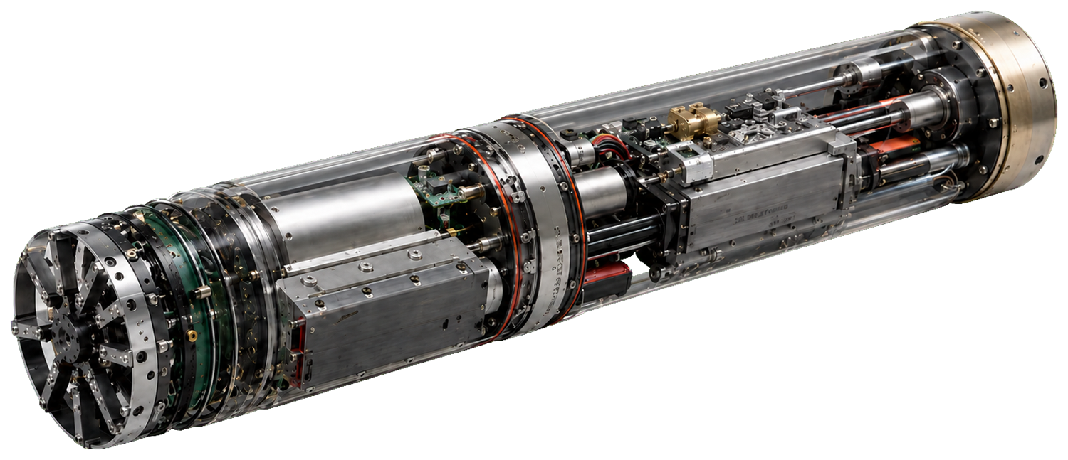
- Excavation & advancement
- Geological sensing & sampling
- Localization & orientation
- Continuous material handling
Below the surface, uncertainty changes everything.
- 01
Limited visibility into changing ground.
Conditions can shift without warning. Underground work often advances with far less information about the material ahead than the risk warrants.
- 02
Fragmented workflows.
Advancement, navigation and geological investigation are typically handled by separate tools and teams that rarely share one live picture.
- 03
Information that arrives too late.
Decisions frequently rely on data gathered before - or outside - the active operation, by which time the ground it described may already have changed.
One continuous underground intelligence loop.
Conventional ground investigation happens in separate, sequential steps - each adding delay before the ground is understood. The Solid Space vision folds them into a single continuous operation.
- 01Borehole
- 02Laboratory analysis
- 03Survey interpretation
- 04Excavation
- 05Updated geological information
Sequential steps introduce a time delay before the ground is understood.
- 01Advance
- 02Survey
- 03Classify
- 04Navigate
- 05Update geological model
- 06Continue
All performed within a single continuous operation.
Four capabilities, engineered as one system.
- 01ADVANCE
Controlled progress through the ground.
Gilimole 2 is designed to move forward through soil and rock in a controlled, repeatable way - the physical foundation every other capability builds on.
- 02EXCAVATE + REMOVE
Mechanical excavation and continuous material handling.
Material is cut and cleared as the platform advances, keeping the face active rather than stopping to clear between stages.
- 03NAVIGATE
High-precision underground localization and orientation without GNSS.
Knowing position and heading below the surface, with no line of sight to satellites. The planned system combines inertial sensing, geological references and platform-state data through sensor fusion.
- 04SURVEY + CLASSIFY
Reading and classifying the ground during operation.
Sensing is designed to characterise the surrounding material while the platform moves - so the ground is read as work happens, not only before it.
The ground becomes a live source of information.
As Gilimole 2 advances, sensing and classification are designed to reveal changes in the surrounding material - connecting position, navigation and geological information into a continuously updated understanding of the ground, and supporting better-informed decisions while work is underway.
A geological cutaway diagram showing Gilimole 2 advancing along a path. As it moves, a sensing field reads the surrounding material, transitions between ground types are marked, and the readings build an interpreted ground profile shown as a colour-coded column.
- Continuous mapping of the ground during advancement.
- Online identification and classification of soil and rock conditions.
- Detection of transitions, weak zones, voids and anomalies.
- Estimation of ground parameters from fused sensor data.
- An evolving digital model of the surrounding ground.
- Decision support for advancement strategy and risk.
Illustrative concept. Zones and transitions are shown qualitatively; no measurement values, depths or specific formations are implied, and advanced outputs are described as designed or intended where validation is ongoing.
Two interacting paths - one closed loop.
The planned system pairs a physical operation path with a data and intelligence feedback path. Sensors collect data as the platform advances; a future fiber-optic link carries it to an above-ground computer, where AI-assisted interpretation is designed to classify the ground and feed that understanding back into navigation and mission control.
Future system architecture, shown as two interacting paths forming a closed loop. The physical operation path runs Operator, Mission control, Navigation, Excavation, Material removal. During operation, geological sensors feed a future data and intelligence path: Geological sensors, Fiber-optic data link, Above-ground AI decision support, Ground intelligence database. The resulting ground intelligence feeds back into Navigation and Mission control, closing the loop. The data path is a future capability.
- Ground scanning
- Material classification
- Rock hardness
- Water detection
- Geological layer identification
- Live 3D geological model
This complete chain represents the future system. Current work covers sensing and integration - not a fully operational live model.
Where the work stands today.
Active areas of development. These are in progress - not finished, operational, or autonomous capabilities.
- Integrated prototype developmentIn development
- Functional excavationIn development
- Continuous material removalIn development
- Navigation moduleIn development
- Geological sensing integrationIn development
- AI decision-support developmentIn development · future direction
- Bench testingIn development
From integrated capabilities to autonomous operation.
- TodayCurrent
Integrated capabilities, operated non-autonomously.
Advancement, excavation and removal, navigation, and ground survey and classification working together on one platform under operator control.
- In developmentDeveloping
Tighter connection between sensing, navigation and decision support.
The path forward links machine state, navigation and real-time sensing more closely, so the platform can support decisions with a fuller live picture.
- VisionFuture
Autonomous coordination of the system.
The long-term vision is a platform intended to coordinate advancement, sensing and navigation for autonomous underground operation. This does not exist today.
Where a platform like this could matter.
These are potential directions, not current deployments - settings where combined advancement and ground understanding could be valuable.
- 01
Underground infrastructure
Utilities, services and connections beneath developed areas.
- 02
Tunneling & subsurface development
Advancing and characterising ground for tunnels and subsurface works.
- 03
Geological investigation
Gathering ground information continuously rather than from isolated points.
- 04
Mining-related environments
Exploration and understanding of material in mining-adjacent settings.
- 05
Remote or constrained operations
Settings where sending people or large equipment is difficult or costly.
Explore what Gilimole 2 could make possible below the surface.
For investors, evaluation programs, and partners who want to understand where the platform is today and where it is heading.